MANTRA ALL CLICKABLE
During the initial construction of the Mariinsky water system (1799 - 1808) "in the gorge", where the Vytegra River "... is surrounded by high rocky mountains and makes several meanders", one- and two-chamber wooden locks of St. Andrew were installed (at 32- 1st verst from Vytegra near the village of Veliky Dvor), St. Samson and St. Michael, and below - the three-chamber gateway of St. Paul (on the 30th verst near the village of Parfeevskoye). Each lock chamber was 15 fathoms long and 30 feet wide. There were dams at the locks. With a rare exception on the Vytegra River (the lock of St. Andrew), all locks were arranged in diversion (supplying water) canals dug in the meanders of the river. In 1890 - 1896, a winding section of the channel 1.5 miles long was taken out of the water system by digging.
Throughout the Mariinsky waterway there were two most significant excavations: Perekop No. 1 near the village of Devyatiny (437.75 fathoms in rocky soil with the bottom laid at a depth of 11.01 fathoms from the surface) and Lukovetsky excavation on the Sheksna River. Devyatinsky perekop was the most grandiose building reconstruction of the Mariinsky water system in 1890 - 1896. The work was carried out by constructing a tunnel along the so-called English way, which was used in England, America, Italy, Switzerland and Austria. In Russia, this method was applied for the first time.
The essence of the tunnel method was that at the level of the bottom of the future channel, a tunnel adit was carried out, which communicated with the surface by a number of shafts. The soil broken out on the surface was thrown off through the channels of the mines into the adit, where the rolling stock cars stood under the holes of the mines. The soil was taken out of the adit and dumped under the overpass along which the train was moving. The path for transporting soil from the dig went along the slope of the left bank and, bypassing the village of Kamennaya, went along a wooden overpass (340 fathoms long and 6 fathoms high) to a low meadow, which subsequently disappeared under the poured soil.
Two locomotives with rolling stock moved along the rails, each consisting of 45 wagons (3 wagons for each of the 15 mines). Upstairs at each mine, 16 people worked, downstairs in the adit - two. Breaking was done by hand with little support from blasting. During these hard work unexpected obstacles appeared, for example, in one part of the dig, a layer lay under the slabs, consisting of alternating layers of stone and clay of all colors and compositions, all this mass began to move with the onset of thaws.
An average of 1200 people and 500 horses were involved in permanent work. There were not enough workers. Food and technical supplies went intermittently in autumn and spring, and in winter it was very expensive, since only horse-drawn vehicles (horses) could be used. In one of the winters hit thirty-degree frosts. One year of construction coincided with a crop failure. Twice there was a threat of a cholera epidemic.
Devyatinsky perekop. The locomotive is loaded train. 1893 
The construction of Perekop No. 1 took five and a half years. The excavation volume amounted to more than 80 thousand cubic sazhens, including 5 - clay soil and 76 - slab and stony (dolomitic) limestone (respectively 786, 48.5 and 737.5 thousand cubic meters. The first Russian experience of the tunnel method of canal construction exceeded all previously known ones by six times in terms of scope of work.
Perekop bypassed the bend of the river, where the locks of St. Samson and St. Michael stood. Three sluices, each 50 sazhens long, were equipped in the perekop itself. In technical terms, three locks at one dam with distances between chambers of 125 sazhens were actually one three-chamber lock.
Today in the river valley you can see the remains of a whole complex of wooden hydraulic structures of the old Mariinsky different years the buildings. A little lower than the mouth of the White Creek in the channel of the Vytegra-Mariinka are the ruins of the dam and St. Andrew's lock. The log fortifications of the walls of the former lock chamber and the fallen gates remained. The active channel, when turning into a perekop, is blocked by the remains of the St. Samson dam and the wooden structures of the St. Samson lock of the first construction. The artificial origin of the dig is easily determined by the rectilinear direction and even slopes.
In the lower part of the sides of the dig, the remains of fastenings of coastal slopes are visible in places. The locks of St. Samson, St. Michael and St. Vladimir (downstream, respectively, No. 25, 24, 23), once standing in the dig, now represent the remains of the log structures of the side walls and the bottom of the chambers and iron rods that fastened the wooden structures to " stone" slopes of the dig. You can even "guess" technical features camera devices.
The “floor” of the bottom of the chambers of the two upper locks, which has not survived, was laid on beds attached to limestone slabs, and the St. Vladimir lock chamber had a pile foundation. Half-decayed beds in one place and the remains of a pile foundation in another place can still be distinguished. It is virtually impossible to restore the appearance of the first locks of St. Michael at least in general terms from fragments of wooden structures and pile fortifications in the riverbed.
In 1887, bypassing the Matkozero, the Novo-Mariinsky connecting canal was built with a total length of about 9 versts, including 2 versts 7 sazhens of the old canal (from the mouth of the first canal to St. Peter's lock). There were only two gateways on the new channel. Vessels were lifted to the watershed stretch of the canal through the St. Alexander lock, and the passage to the Baltic branch was carried out by the St. Peter lock.
The area around the canal and locks was completely open. A verst from the lock of St. Peter there was an obelisk erected in honor of Peter I by General Devolant. From the monument one could see the hollow of the Matkozero, which was lowered in 1886. On the fifth verst of the new canal, aside from the Alexander lock, the remains of the former Konstantinovsky water pipeline remained for a long time. The design of this structure could be understood even in the pre-war years of the 20th century.
St. Xenia Dam on the Vytegra River. 1909
Many people have probably heard about the pioneer of color photography in Russia, Sergei Mikhailovich Prokudin-Gorsky. His unique "Collection of sights of the Russian Empire" flashes on many resources. Color photographs dating back to the beginning of the last century immortalized many moments from the life of the country even before the revolution. And, given that Prokudin-Gorsky greatly respected travel by water, many waterways have been preserved in his collection.
In 1948, 4 years after the photographer's death, his entire collection was bought from his heirs by the US Library of Congress and appeared in open access only in the 2000s. I will try to upload in several posts the main photographs from the collection of Sergei Mikhailovich concerning waterways and shipping in Russia at the beginning of the 20th century. I hope the public will be interested.
Part one. Mariinsky system. The rivers Kovzha, Vytegra, Sheksna and White Lake.
In 1909, long before the appearance of the Volga-Baltic Canal, S. M. Prokudin-Gorsky traveled along the Mariinsky sluice system - the then waterway from the Volga to St. Petersburg on the steamer "Sheksna".
#1. 1909 The crew of the steamer "Sheksna", on which S. M. Prokudin-Gorsky traveled through the Mariinsky system.
Under the cut of his "photo report on the cruise."
#2. Chapel on the site where the city of Belozersk was in ancient times.
1909 Belozersk. The village of Krokhino (now flooded).
#3. Belozersk. General form cities from the city rampart.
#4. Belozersk. General view of the city from the city wall.
#5. Belozersk. Church of St. Basil the Great (left) and Cathedral of the Transfiguration (right) inside the ramparts. Belozersk. Basil the Great Church (left) and Transfiguration Cathedral (right) inside the ramparts.
#6. On the river Vytegra. 1909
Before the construction of canals and locks, Vytegra was just like that.
#7. Dam of St. Xenia.
1909 The dam was located 6 kilometers above the city of Vytegra on the Vytegra River.
#8. Tanker barge of the Nobel brothers on the Vytegra river.
#9. Temple in the name of the Assumption of the Mother of God in the village of Devyatiny (R. Vytegra).
#10. Nine. Repair shop of the Ministry of Railways and a lock (on the Vytegra River).
#eleven. Nine. Garden of the Ministry of Railways and St. Paul's Gateway (on the Vytegra River).
#12. Nine. Dam of Saint Paul.
#13. Chapel for the blessing of water in Devyatyny.
#14. Vytegra. General view of the city and the Vytegra river.
#15. Drawbridge on the Vytegra River.
#16. Vytegra. Church of the Ascension.
#17. Canal "Vytegra-Kovzha" and a memorial sign to Emperor Alexander II in memory of the end of the Mariinsky system.
#18. Goritsy. The main cathedral of the Goritsky Monastery from the road.
#19. Goritsy. View of the monastery from Mount Maura.
#20. Goritsy. General view of the monastery (from the Sheksna River).
#21. Kirillov. Kazan Cathedral.
#22. Kirillov. General view of the city from the bell tower of the Kazan Cathedral.
#23. Kirillov. View from Mount Maura.
#24. Kirillov. Holy Gates of the Kirillo-Belozersky Monastery.
#25. Kovzhskaya dam.
1909 It was located near the source, was built in the 19th century as part of the Mariinsky water system.
#26. Kovzhskaya dam.
#27. Kovzha river. The village of Kovzhinsky sawmill.
#28. Sheksna river. Coastal fortifications.
#29. Kovzhinsky sawmill.
#thirty. The village of Kovzhinsky plant.
#31. The settlement of the Kovzhinsky plant - residential buildings.
#32. Vokhnovo town. The Sheksna River, about 20 kilometers from Cherepovets.
#33. Sheksna river. Dam and lock of Emperor Nicholas II.
#34. The Sheksna River at the confluence with the Belozersky Canal. Old lock gates.
#35. Sheksna river. Gorodetsky and Nikitsky churchyards (not far from Goritsy).
#36. On the cabin of the steamer "Sheksna".
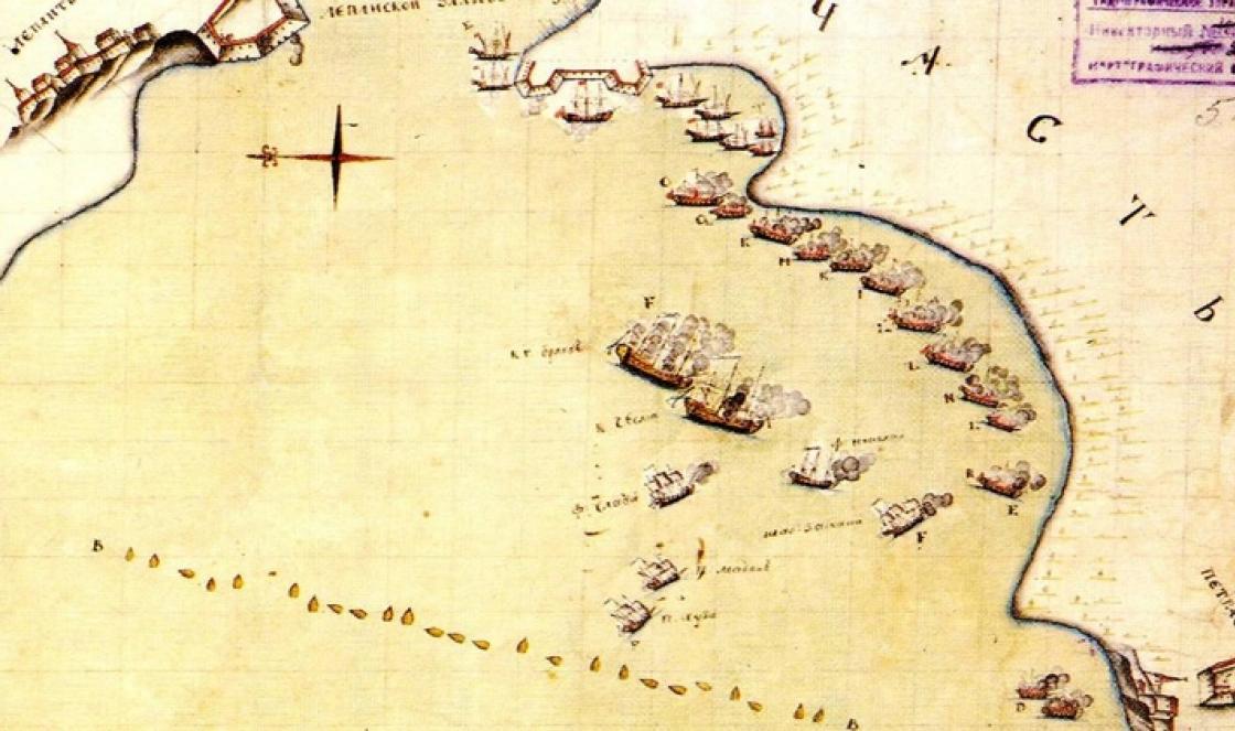
The Mariinsky water system is a waterway in Russia connecting the Volga basin with the Baltic Sea. From Rybinsk to the St. Petersburg sea port through the Ladoga canals (1054 versts). Consists of both natural and artificial waterways: r. Sheksna - White Lake - r. Kovzha - Mariinsky Canal - r. Vytegra - Lake Onega - r. Svir - Ladoga canals - r. Neva. It was under the jurisdiction of the Vytegorsky and St. Petersburg districts of communications. The construction of the waterway was necessary Russian Empire to supply St. Petersburg (as the capital and the largest city in terms of population) with bread, timber, firewood and other products, goods for foreign trade, delivered through Rybinsk from the lower reaches of the Volga. For the grain trade in Rybinsk, the Grain Exchange was set up. Subsequently, wheat was exported to Europe through the Mariinsky system. The construction of the system with a length of over 1125 km took place during the reign of Paul I and his son Alexander I, and took 11 years. In connection with the development of capitalism after the abolition of serfdom, the capacity of the Mariinsky Canal was recognized as insufficient. In August 1882, work began on its modernization (the so-called Novomariinsky Canal). Construction work was completed in 1886. Following this, the construction of the Novosvirsky and Novosyassky canals (bypass near Ladoga) began. The restructuring of the canals was led by engineer K. Ya. Mikhailovsky. In 1890, the Ministry of Finance allocated 12.5 million rubles for the reorganization of the system. The work began on October 28, 1890. They were led by engineers from the Vytegorsky and Novoladozhsky districts of communications: A. Zvyagintsev, K. Balinsky, A. Valuev, A. Moguchy, V. Martynov. Total: 38 locks (on Vytegra - 28, on the Novo-Mariinsky Canal - 2, on Kovzha - 2, on Belozersky - 2, on Sheksna - 4) and 26 dams (on Vytegra - 14, on Kovzha - 4, Belozersky Canal - 4, on Sheksna - 4). Four stone locks were built (without No. 35, No. 36 and No. 37), each 150 sazhens long and 6 sazhens wide; with metal gates, collapsible dams of the Poiret (Poare) system. Perekopy (total length of 20 miles): No. 1 Devyatinsky on Vytegra; Kopanovsky (on the 21st verst from the source), Krestovy, Alekseevsky, Maryinsky, Probudovsky (on the 45th verst), Lukovetsky (791 sazhens; shortened the path by 7 versts) on Sheksna. Cleared from influxes and sediments, deepened and expanded lakeside bypass channels. In some places, towpaths have been renewed, in some places new ones have been built. The rapids on the Svir have been partially cleared, corrective and water restraint structures have been built, and the ship's passage has been widened and deepened. On June 15/27, 1896, a celebration of the opening of the rebuilt system took place in Chernaya Gryad in the presence of Grand Duke. book. Vladimir Alexandrovich, Minister of Railways M. I. Khilkov. At the World Paris Exhibition of 1913, the Mariinsky System was awarded the Big Gold Medal. With the completion of the construction of the Volga-Baltic waterway, most of the Mariinsky water system became part of it. The system, reconstructed in 1959-1964, was named the Volga-Baltic Waterway. V. I. Lenin. During the initial construction of the Mariinsky water system (1799 - 1808) "in the gorge", where the Vytegra River "... is surrounded by high rocky mountains and makes several meanders", one- and two-chamber wooden locks of St. Andrew were installed (at 32- 1st verst from Vytegra near the village of Veliky Dvor), St. Samson and St. Michael, and below - the three-chamber gateway of St. Paul (on the 30th verst near the village of Parfeevskoye). Each lock chamber was 15 fathoms long and 30 feet wide. There were dams at the locks. With a rare exception on the Vytegra River (the lock of St. Andrew), all locks were arranged in diversion (supplying water) canals dug in the meanders of the river. In 1890 - 1896, a winding section of the channel 1.5 miles long was taken out of the water system by digging. Gateway of Empress Maria Feodorovna on the Mariinsky canal system
Throughout the Mariinsky waterway there were two most significant excavations: Perekop No. 1 near the village of Devyatiny (437.75 fathoms in rocky soil with the bottom laid at a depth of 11.01 fathoms from the surface) and Lukovetsky excavation on the Sheksna River. The Devyatinsky perekop was the most grandiose construction of the reorganization of the Mariinsky water system in 1890-1896. The work was carried out by constructing a tunnel according to the so-called English method, which was used in England, America, Italy, Switzerland and Austria. In Russia, this method was applied for the first time. The existing fairway at the St. Alexey. 1892
The essence of the tunnel method was that at the level of the bottom of the future channel, a tunnel adit was carried out, which communicated with the surface by a number of shafts. The soil broken out on the surface was thrown off through the channels of the mines into the adit, where the rolling stock cars stood under the holes of the mines. The soil was taken out of the adit and dumped under the overpass along which the train was moving. The path for transporting soil from the dig went along the slope of the left bank and, bypassing the village of Kamennaya, went along a wooden overpass (340 fathoms long and 6 fathoms high) to a low meadow, which subsequently disappeared under the poured soil. The laying of the king on the gateway of St. Nicholas. 1892
Two locomotives with rolling stock moved along the rails, each consisting of 45 wagons (3 wagons for each of the 15 mines). Upstairs at each mine, 16 people worked, downstairs in the adit - two. Breaking was done by hand with little support from blasting. During these difficult works, unexpected obstacles appeared, for example, in one part of the dig, a layer lay under the slabs, consisting of alternating layers of stone and clay of all colors and compositions, all this mass began to move with the onset of thaws. The device for digging at the gateway of St. Alexey. 1892
An average of 1200 people and 500 horses were involved in permanent work. There were not enough workers. Food and technical supplies went intermittently in autumn and spring, and in winter it was very expensive, since only horse-drawn vehicles (horses) could be used. In one of the winters hit thirty-degree frosts. One year of construction coincided with a crop failure. Twice there was a threat of a cholera epidemic. Devyatinsky perekop. The locomotive is loaded train. 1893
The construction of Perekop No. 1 took five and a half years. The excavation volume amounted to more than 80 thousand cubic sazhens, including 5 - clay soil and 76 - slab and stony (dolomitic) limestone (786, 48.5 and 737.5 thousand cubic meters, respectively. The first Russian experience of the tunnel method of canal construction exceeded volume of work all previously known by six times.
Perekop bypassed the bend of the river, where the locks of St. Samson and St. Michael stood. Three sluices, each 50 sazhens long, were equipped in the perekop itself. In technical terms, three locks at one dam with distances between chambers of 125 sazhens were actually one three-chamber lock. Dredging machine Mariinsky 5th. Kovzha River. 1909
Today, in the river valley, you can see the remains of a whole complex of wooden hydraulic structures of the old Mariinsky from different years of construction. A little lower than the mouth of the White Creek in the channel of the Vytegra-Mariinka are the ruins of the dam and St. Andrew's lock. The log fortifications of the walls of the former lock chamber and the fallen gates remained. The active channel, when turning into a perekop, is blocked by the remains of the St. Samson dam and the wooden structures of the St. Samson lock of the first construction. The artificial origin of the dig is easily determined by the rectilinear direction and even slopes. Kovzhskaya dam. 1909
In the lower part of the sides of the dig, the remains of fastenings of coastal slopes are visible in places. The locks of St. Samson, St. Michael and St. Vladimir (downstream, respectively, No. 25, 24, 23), once standing in the dig, now represent the remains of the log structures of the side walls and the bottom of the chambers and iron rods that fastened the wooden structures to " stone" slopes of the dig. You can even "guess" the technical features of the camera device. The “floor” of the bottom of the chambers of the two upper locks, which has not survived, was laid on beds attached to limestone slabs, and the St. Vladimir lock chamber had a pile foundation. Half-decayed beds in one place and the remains of a pile foundation in another place can still be distinguished. It is virtually impossible to restore the appearance of the first locks of St. Michael at least in general terms from fragments of wooden structures and pile fortifications in the riverbed. In 1887, bypassing the Matkozero, the Novo-Mariinsky connecting canal was built with a total length of about 9 versts, including 2 versts 7 sazhens of the old canal (from the mouth of the first canal to St. Peter's lock). There were only two gateways on the new channel. Vessels were lifted to the watershed stretch of the canal through the St. Alexander lock, and the passage to the Baltic branch was carried out by the St. Peter lock. On the river Vytegra. 1909
The area around the canal and locks was completely open. A verst from the lock of St. Peter there was an obelisk erected in honor of Peter I by General Devolant. From the monument one could see the hollow of the Matkozero, which was lowered in 1886. On the fifth verst of the new canal, aside from the Alexander lock, the remains of the former Konstantinovsky water pipeline remained for a long time. Monument in honor of the completion of the construction of a new connecting (Novo-Mariinsky) canal between the rivers Vytegra and Kovzha. Gateway of St. Alexander. 1909
St. Xenia Dam on the Vytegra River. 1909
Dam of St. Pavel in Devyatiny. 1909
Repair shop M.P.S. in Nine. Vytegra river. 1909
The Volga-Baltic waterway is the name given to the grandiose transport system of waterways, stretching for 1100 km in the northwestern part of Russia and connecting the Baltic Sea and the river. Volga. It is a complex link in a single deep-sea communication system for the entire European part Russian Federation, which combines transport lines that go to the White, Baltic, Black, Caspian, and Azov seas.
(VBVP) passes through:
- Rybinsk reservoir;
- lakes: White, Onega, Ladoga;
- rivers: Sheksna, Kovzha, Vytegra, Neva, Svir;
- channels: Mariinsky, Onega, Volga-Baltic (Volgo-Balt).

Drawbridge pontoon automobile bridge across the Volga-Baltic Canal in the village of Annensky Bridge
VBVP has a minimum width of 50-70m with a depth of 4m and allows the passage of ships with a carrying capacity of up to 5000 tons. Most of them are self-propelled cargo ships carrying cargo without transshipment. The most important goods transported by this waterway are:
- iron ore concentrate - through Kandalaksha from the Kola Peninsula to the Cherepovets Iron and Steel Works;
- Cherepovets ferrous metals, Donbass and Kuzbass coal, potash salts from Solikamsk, pyrites from the Urals - to supply the northwestern regions and for export;
- Khibiny apatites and apatite concentrate, Karelian granites and diabase, cereals - to different regions of the country;
- timber, lumber from Vologda, Arkhangelsk - to St. Petersburg, the southern regions of the country and for export;
- Baskunchak salt - to Murmansk;
- oil and products of its processing - to the northwestern regions, the Baltic states, for export;
- imported goods - from St. Petersburg to different regions of Russia.
Passenger routes connect St. Petersburg with Moscow, Rostov-on-Don, Perm, Astrakhan, and most river cruises to the "northern capital" also go along this route.

Volga-Baltic Canal
Crossing Annensky bridge
The history of the waterway is rooted in the creation Mariinsky water system built in the 19th century. After its major reconstruction in the 60s of the last century, it was named the Volga-Baltic Waterway.

Since the 18th century, access to the Baltic Sea has been a strategic goal for Russia. This was also facilitated by the growing importance new capital- Petersburg, which required the establishment of a convenient transport communication, including water, with all the internal regions of the state.
To solve these problems, water systems were created and opened:
- in 1709 - Vyshnevolotskaya;
- in 1811 - Tikhvinskaya;
- in 1810 - Mariinsky.
The last system, starting near Rybinsk, passed further along rivers, lakes, and the artificial Mariinsky Canal. It also included bypass channels created to ensure the safety of navigation of small vessels plying on the Ladoga, White, Onega lakes:
- Onega;
- Novoladozhsky;
- Belozersky.

The economic significance of the Mariinsky system for that time can hardly be overestimated. At that time, it was an outstanding hydraulic structure, however, it soon ceased to meet the growing transport needs of the country, which led to the need to search for new modern solutions.

Plan
Introduction
1. History
2 Funding
2.1 Construction
2.2 Modernization
3 System description
4 Disadvantages
5 Construction of bypass channels
5.1 Onega Canal
5.2 Belozersky Canal
Bibliography
Introduction
Mariinsky water system - water system in Russia, connecting the Volga basin with the Baltic Sea. Consists of both natural and artificial waterways.
The construction of the water system with a length of 1145 km lasted 11 years. IN Soviet time was named Volga-Baltic waterway them. V. I. Lenin .
1. History
Research in the direction of this path - r. Vytegra - r. Kovzha - r. Sheksna was held several times: under Peter and in 1774, 1785 and 1798.
In 1785, they were carried out by engineer Jacob de Witte, who made a preliminary and then completed project and an estimate in the amount of 1,944,000 rubles. On December 31, 1787, Catherine II allocated 500,000 rubles for the construction of the Vytegorsk Canal. But they were soon plundered (a small amount), work did not even begin. But the need for the supply of goods to St. Petersburg was so high that the head of the Department, Count Yakov Efimovich Sievers, had to deal with the design issue. He personally made a reconnaissance of the route and presented the tsar with a report on the construction in the Vytegorsk direction.
But the work plan and estimate were taken from John Perry, who developed the same route under Peter (the de Witte project was not considered and was not even mentioned in the reports).
2. Financing
Funding is a very important element in construction and is quite unique for this waterway. To carry out the work, they took money from the fund educational homes that is, those that were collected for the maintenance of illegitimate children, foundlings and orphans, taking away their food, clothing, shelter and education. Empress Maria Feodorovna was in charge of this fund.
On January 20, 1799, Paul signed a decree: “We commanded, accepting this amount as a loan from this place on the subject conditions, to add it to other amounts allocated by water communication, and the channel in expression of Our gratitude for such an advancement of Her Imperial Majesty and as a keepsake for posterity , We deign to call the Mariinsky.
2.1. Construction
The management of the construction of the system was entrusted to the engineer-general Franz Pavlovich de Vollant (also the spelling of his last name is found in the sources as Devolant), for which a special department was created under him.
Construction began in 1799. The system was built by the Department of Water Communications, which was headed by N.P. Rumyantsev. According to the original plan, it was planned to build 26 locks, and in 1801 8 of them were built and a connecting channel was dug. Somewhat later, two locks not provided for by the project were built in the Shestovskaya and Belousovskaya rapids of the river. Vytegra. In 1808, the first ship with a draft of less than 1 m passed from Kovzha to Vytegra.
On July 21, 1810, the opening of shipping on the Mariinsky water system was officially announced. The construction cost amounted to 2,771,000 rubles.
2.2. Modernization
During the 19th century, the Mariinsky water system underwent a number of alterations.
In August 1882, work began on the creation of the Novomariinsky Canal - connecting the Kovzha and Vytegra rivers, then the Novosyassky and Novosvirsky canals. The restructuring of the canals under the guidance of engineer K. Ya. Mikhailovsky ended in 1886.
With the completion of the construction of the Volga-Baltic waterway, most of the Mariinsky water system became part of it.
3. Description of the system
The whole system looked like this:
Gateway on Kovzha - St. Constantine, St. Anna and one semi-gateway. 9 km from St. Anna, a connecting canal was dug to the village of Upper Frontier. There are 6 gateways on the channel. Matkoozero was a watershed point. There are 20 locks on Vytegra. All locks had a chamber length of 32 m, a width of 9 m and a depth at the threshold of 1.3 m. The system was fed from Lake Kovzha, for which its level was raised by 2 meters by blocking dams at Kovzha and Puras.
The length was 1,145 km, along the route (from Rybinsk to St. Petersburg, on average, it took 110 days to get there) there were 28 wooden locks.
4. Disadvantages
The small size not only limited the possibility of increasing the cargo turnover, but also could not let the ships going through the Vyshnevolotsk system pass to Rybinsk. Beloe and Onega lakes did not have bypass channels and the ships perished in them even with a slight wave. The route itself passed through deserted and sparsely populated, swampy areas. It was impossible to find enough people and horses to pull the ships and serve the navigation.
5. Construction of bypass channels
5.1. Onega Canal
In 1818, they began to build a canal on the site from the river. Vytegra to the Black Sands tract. The length of the channel is 20 km. From Black Sands to Ascension they dug right up to 1852.
5.2. Belozersky Canal
Opened in August 1846. Passed by the southern shore of the lake with dimensions: width along the bottom 17 m, depth 2.1 m, length 67 km. It had two gateways from the Sheksna side - "Convenience" and "Safety", and one from the Kovzha side - "Benefit".
Bibliography:
1. Margovenko, Alexey"Roads of the Tsars" (Russian). magazine "Ural" 2004, No. 10.